Sunday, February 28, 2010

A Motto To Live By

When we were out and about in our rental van on Long Island, we stopped at Max’s Conch Bar for a drink and some conch salad. It’s quite a funky little place—round, with a thatched roof and bar stools, only a couple of small tables—with locals and tourists alike having a great time. The under-thatch ceiling is covered with license plates, t-shirts, and pictures, and this saying below that we really liked.

Dean’s Blue Hole

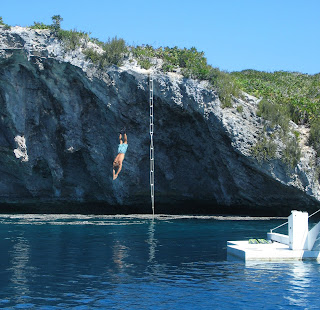
Is this not one of the prettiest places you’ve ever seen?

It’s Dean’s Blue Hole on Long Island, where we sailed to from the Jumentos Cays. Serendipitously, we met up with old friends—John and Roberta on Freedom, and Jason and Laura on Blue Blaze—at Salt Pond, Long Island, and we all rented a mini-van and travelled down to the blue hole for a day. And what a day! The blue hole, which is tucked up in the corner of this bay, is the deepest in the world, descending abruptly from the sandy rim to 660 feet in the hole itself. The white platform is used for freediving competitions. In freediving, the diver goes to depth (sometimes on a weighted sled) and back without any air source. As we arrived, one of the champions was just leaving; he’s gone to nearly 400 feet—no thanks! We snorkeled and had a picnic lunch, and climbed the surrounding cliffs to take advantage of the wonderful views, which you can see behind us. Chris even climbed a rope ladder and dove from the cliff rim into the hole; at least he didn’t have to worry about hitting bottom!

Ragged Islands and Jumentos Cays

We spent nearly three weeks in the Ragged Islands and Jumentos Cays, in the southern Bahamas. The chart book we use talks about how isolated these islands are, with cruisers only rarely making that far south. I guess they need to be updated, because it was like George Town South down there. There were plenty of boats, some of them moving in packs, and lots of people on the radio. However, we met lots of really nice people, especially when we attended a beach party on Valentines Day (about 20 boats). Maxine, who owns the store in Duncan Town (that’s the Duncan Town main street in the photo), the only settlement in this sixty-mile chain of islands, hosted the party, and lots of cruisers attended. Great food and great company. For a week we ping-ponged back and forth between two particular anchorages while fronts came through because one anchorage gave good protection from the south and west, while the other anchorage gave protection from the north, but we found time to anchor at some other beautiful spots like Buena Vista Cay (here's the beach on the cay’s western shore). The fishing here fantastic, and we ate some fish and lots of lobster (like this beauty in the pot). The folks on Side By Side, whom we met first at Hog Sty Reef and again at Flamingo and Water Cays, taught us that there’s lots of meat in the head and body of the large lobsters, so Chris has been patiently picking out the smaller yet abundant pieces of meat to use in casseroles or lobster omelets.

Tuesday, February 9, 2010

The Two That Got Away

That’s right, not just one, but two. How’s that for a fish story?! Actually, it was two different instances; the first mysterious, the second disappointing. En route to Hog Sty Reef, we had the fishing line out when all of a sudden the line started tearing off the reel. Chris grabbed the pole and started to bring the fish in, with effort, since the fish really didn’t want to come. As he increased the drag on the line, it snapped, and we lost the hook, lure, and most of the reel of line to whatever was at the end of it. That was the mystery—what was on the line? Chris replaced the line on the fishing pole with heavier stuff, so the next fish wouldn’t snap it. The second time, just past dawn off of the southern end of the Ragged Islands, we knew exactly what we had: a three-foot long wahoo . Chris got the fish to the boat and and out of the water, then Anne took the fishing pole (that’s why there’s only a picture of the fish underwater!) so Chris could grab the fish while avoiding its mouthful of sharp teeth. But before he could get a good hold on it, the clasp on the leader broke and the fish dropped back into the depths. That was the disappointment, because wahoo is tasty, and that fish would have fed us for several days. At least it wasn’t the line that broke this time, but we’ve decided that when we get back to George Town, we’re going to buy a gaff.

Hog Sty Reef

Talk about the middle of nowhere. Hog Sty Reef is a barely submerged reef between Acklins Island and Great Inagua. The reef itself surrounds an oval-shaped lagoon about five miles east to west and less than three mile north to south. Water depths average six meters inside, and more than 1,000 meters just offshore. This picture shows the spit of land at the opening to the reef, on the western end. It does have a working light, which is good, so you could avoid it at night. That’s it for land, except for an even smaller bit of sand on the southern side of the reef. The first signs that you’re approaching Hog Sty Reef are the huge shipwreck on the northern reef, then the smaller wreck on the southern reef. We came here during a couple of days of relatively calm weather, and met up with Side By Side, a catamaran with a family of four who have been cruising for four winters, and are in their last four months before moving back to New York so the kids can go to school. We snorkeled the wrecks with them, then we all enjoyed sundown and a few lobsters for dinner. They had just caught a five-foot mahi, which they kindly shared with us, and they gave us tips on places to go in the Ragged Islands. Great people! There are numerous reefs scattered throughout the lagoon; we snorkeled several of them, and would have kept at it if we didn’t need to get moving due to weather. This would NOT be a good place to weather out a storm (Remember the wrecks?). If you can get here, it’s a terrific place to spend a few days, especially if you like quiet isolation, which is right up our alley.

Thar Be Whales!

Anne has been dying to see whales since we started cruising. No luck. However, the banks near the Turks and Caicos islands, about fifty miles south of Mayaguana, are wintering grounds for humpback whales, so we thought we might have a better chance around here. We set off one day for East Reef, at the eastern end of Mayaguana, keeping half an eye out for whales. And we saw them! The first sign was a disturbance on the surface about twenty feet from the boat, indicating that something large had recently sounded. Unfortunately, we missed them that close, but saw them about half a mile away. There were five or six, and they weren’t humpbacks, but they were definitely whales. Woo hoo!

Mayaguana

Mayaguana is a relatively large island north of the Turks and Caicos. We stayed in there about a week, first snorkeling and feasting on fish and lobster, then waiting out some weather. Abrahams Bay, in the southwest corner of the island, is a large area with lots of reefs and several great anchorages. The kind of scary thing about it is that the bay is enclosed by reefs that are just submerged beneath the surface. On a calm day, you really can’t tell it’s there, and it would be really really easy to plow right into it if you didn’t have charts and weren’t paying attention, because the water is deep (greater than 100 meters) to about ¼ mile from the reef, then shallows quickly. So it’s kind of nice when there are at least light breakers showing the reef edge. But the reef keeps the bay much calmer than the open water outside, and there’s good sand to anchor in. The dinghy landing, although a little worse for wear, has a nice welcoming sign and some picture-perfect coconut palms. Just along the shore is an old graveyard—each grave had a pile of rocks and one conch shell—not a bad view for eternity! The settlement of Abrahams Bay is a 5-10 minute walk from the landing. The road is line with mangroves, and we saw lots of birds wading in the shallow water. One thing we’ve learned in the Bahamas: head for the Batelco (Bahamas Telephone Company) tower, which you can see in the left side of the photo below. You can see the red-lit towers from miles offshore, and you can generally find a phone (although not always a working phone) and internet access nearby. We went to the island administrator’s office to extend our immigration papers, and sat in their small vestibule to use the wifi, warning people who came in the door not to trip over the power cord. Everyone was very nice and helpful – great people. This was on January 22nd, and we haven’t had internet access until now (February 8th), thus the big silence.